City of Anarchy
This infographic, based on the infamous Kowloon Walled City, is the product of exhaustive research and represents a seminal work in visual journalism and illustrative reconstruction.
I tried meticulously to dissect the legendary settlement, moving beyond its infamous reputation to reveal its crazy internal anatomy.

This backpage print was published in the South China Morning Post on March 15, 2013.
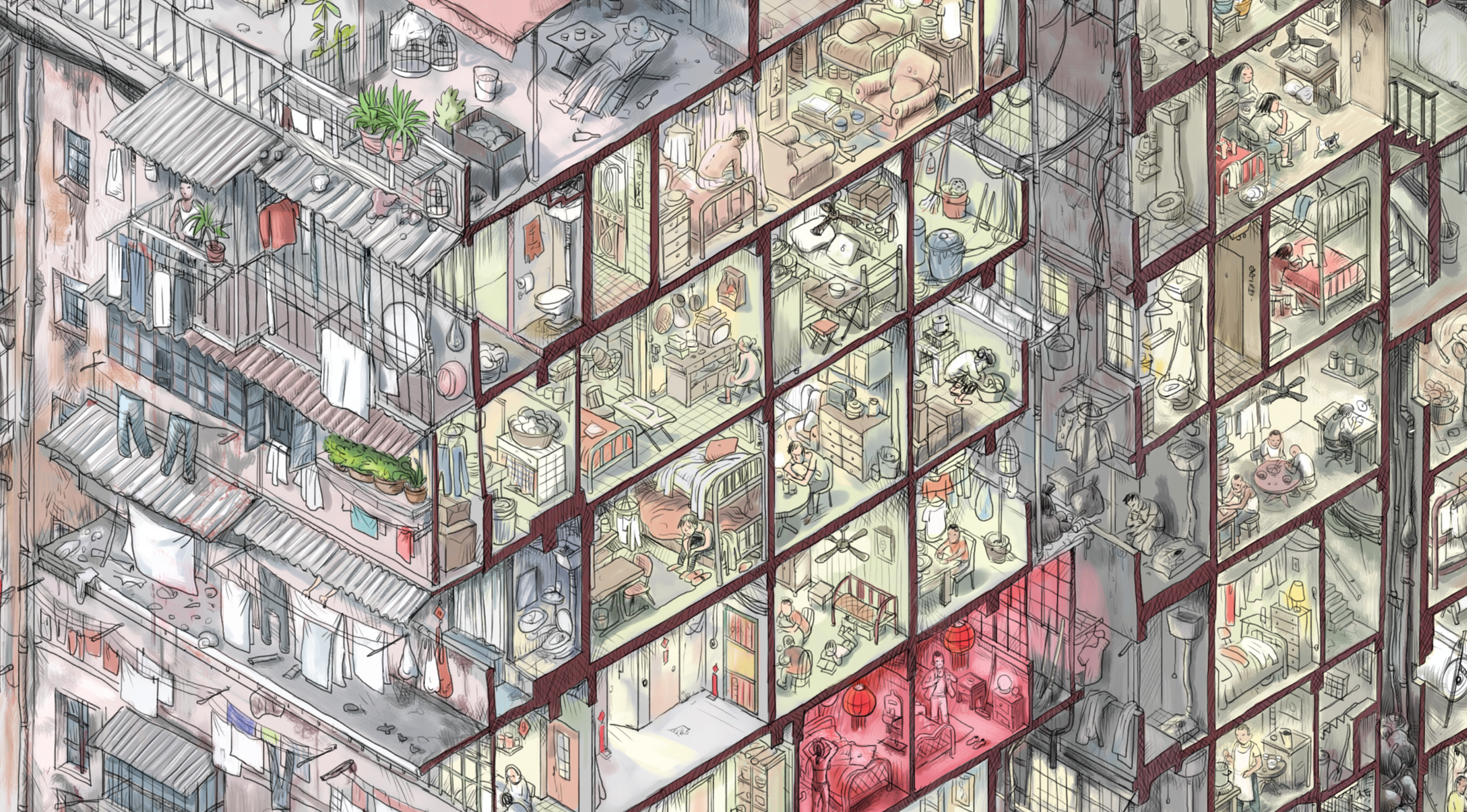
Kowloon Walled City was a unique phenomenon of urban anarchy and self-governance in modern history. Originally a Chinese military fort, it became a notorious enclave within British colonial Hong Kong, existing in a state of legal limbo.

Without any effective administration, it was organically constructed and reconstructed by its residents into a towering, densely packed megastructure.

By the late 1980s, it had become a labyrinthine universe unto itself, home to an estimated 35,000 people living within its mere 2.6 hectares (6.4 acres), making it the most densely populated place on Earth.

It was a place of staggering contradictions—a realm often associated with crime and unsanitary conditions, yet also a vibrant community with factories, clinics, schools, and temples all operating within its dark, interconnected walls.
My process began with exhaustive research on this fascinating place. After gathering all the information I could, I did what any designer does next: preliminary sketches. This is the initial page layout and overall concept, drafted in digital and on my Moleskine notebook.
Preliminare sketches

If you are interested in the details of how I developed this graphic, you can read the post I made on Substack to mark the tenth anniversary of the creation of the "City of Anarchy" infographic.

All the illustrations and graphics shown on this page are under the copyright of the South China Morning Post.
If you are interested in this infographic, the South China Morning Post is selling a quality poster on its website here


Thanks for the visit!
Graphic with Reuters

The Godfather at 50

Ghent Altarpiece

Raining cats and dogs

City of Anarchy

Penned in: the state of Hong Kong’s opposition

Sixteen years of Angela

Safe skies

Cashing in on gold
How Bruce Lee and street fighting in Hong Kong helped create MMA

The China Ship

On the move

Must farm

Arrested development

Tradition or exploitation?

The story of a newspaper

Where coal is king

China's wildlife market

How the coronavirus spread in Hong Kong

A question of taste

Creating a modern monster

They are very close ...
The last days of rosewood